If you need help with your purchase or have a question about this product, contact me, I'll be happy to help you!
Add this product to yourWish list
WarrantyInformation
Fast & Reliable Delivery
across Canada
Returns process
Quick and Easy
Best Online support
+1.877.349.2332
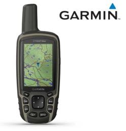
Garmin GPSMAP 65S North America GPS
Rating:
0%
SKU
30335
Garmin GPSMAP 65S North America GPS
Multi-Band GPS Handheld with Sensors
Explore more with this rugged handheld that offers multi-band frequency support for our most accurate position to date, a 2.6” color display and preloaded maps.
Explore more with this rugged handheld that offers multi-band frequency support for our most accurate position to date, a 2.6” color display and preloaded maps.
- DIMENSION: 2.4" x 6.3" x 1.4" (6.1 x 16.0 x 3.6 cm) - DISPLAY SIZE: 1.43" x 2.15" (3.6 x 5.5 cm); 2.6" diag (6.6 cm) - DISPLAY RESOLUTION: 160 x 240 pixels - DISPLAY TYPE: transflective, 65K color - TFTWEIGHT: 7.7 oz (217 g) with batteries - BATTERY TYPE: 2 AA batteries (not included); NiMH or Lithium recommended - BATTERY LIFE16 hours - WATERPROOF: IPX7 - INTERFACE: high speed mini USB and NMEA 0183 compatible - MEMORY/HISTORY: 16 GB (user space varies based on included mapping)
Access multiple global navigation satellite systems (GPS, GLONASS, GALILEO and QZSS) to track in more challenging environments.
MULTI-BAND FREQUENCY SUPPORT
Receive and utilize multiple frequencies sent by navigation satellites which enables improved user position accuracy, specifically in areas where GNSS signals are reflected, weak or typically do not penetrate. Get superior accuracy using state of the art technology, previously only available to the military.
ABC SENSORS
Navigate every trail with ABC sensors, including an altimeter for elevation data, barometer to monitor weather and 3-axis electronic compass.
PRELOADED TOPO MAPS
Preloaded TopoActive U.S. and Canada maps show you terrain contours, topographic elevations, summits, parks, coastlines, rivers, lakes and geographical points.
PUBLIC LAND BOUNDARIES
An optional display of federal public land boundaries on topographical maps helps you know that you’re venturing where you’re supposed to be.
GARMIN EXPLORE APP
Plan, review and sync waypoints, routes and tracks by using the Garmin Explore app1 and website. You can even review completed activities while still in the field.
SMART NOTIFICATIONS
Receive emails, texts and alerts right on your handheld when paired with your compatible device.
GEOCACHING
Get paperless geocaches by uploading GPX files straight to your device. View key information such as location, terrain and hints from Geocaching.com.
MICROSD™ SLOT
Using your compatible device and microSD memory card, conveniently download TOPO 24K maps and hit the trail, or access HuntView Plus maps to see public land types and boundaries as well as private landowner names and boundaries.
MICROSD™ SLOT
Using your compatible device and microSD memory card, conveniently download TOPO 24K maps and hit the trail, or access HuntView Plus maps to see public land types and boundaries as well as private landowner names and boundaries.
 English