English
Talk with Mylene
If you need help with your purchase or have a question about this product, contact me, I'll be happy to help you!


Fast & Reliable Delivery
across Canada
Returns process
Quick and Easy
Best Online support
+1.877.349.2332
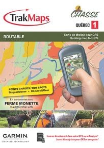
Trak Maps TOPO Québec 7 for GPS Garmin
Trak Maps TOPO Québec 7 for GPS Garmin
- Immediately ready to download
- Tied to one GPS unit
- Transfer to your own microSD card or GPS unit internal memory
- Can be combined with other downloadable maps on your own microSD card or GPS unit internal memory
- Can be installed in Garmin BaseCamp for Windows or Mac
- Save the environment - no packaging used
- High speed Internet connection required
Includes
- NEW Crown land - July 2019
- NEW Ecoforestry layer - July 2019
- NEW National Trail in Quebec from Rando Québec - July 2019
- NEW Routable road network - June 2019
- NEW Recreative territories - March 2019
- NEW Aboriginal lands - August 2019
- Zecs and fishing zones
- Routable forestry roads
- Topographic data including mountains, hills, valleys, lakes, rivers, streams, wetlands
- Hiking trails
- Paddling routes
- Detailed shorelines of lakes and rivers
- National and provincial parks, wildlife reserves
- ATV and snowmobile trails**
- Outfitter & trapper camps, welcome centres, forest shelters
- Boat launch ramps
- Cellular towers
- Buildings, pylons, electric lines, bridges, dams, railroads, other reference points and landmarks
** Unofficial trails included for identification purposes only. We strongly recommend that snowmobile and ATV users acquire the official, federated trails available in TrakMaps ATV Quebec and Snowmobile Quebec.